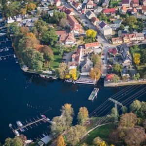
The human desire to explore and understand the world around us has driven countless discoveries and innovations throughout history. From the vast oceans to the highest peaks, we have constantly sought new perspectives to unravel the mysteries of our planet. In this quest for knowledge, one technique has emerged as a powerful tool for unlocking hidden landscapes and gaining invaluable insights: aerial surveys. By taking to the skies, we transcend the limitations of ground-level observation and embark on a breathtaking journey beyond the horizon.
Unleashing the Power of Aerial Survey
Aerial surveys have revolutionized our ability to comprehend and appreciate the natural and man-made wonders that shape our planet. Through the use of aircraft, drones, satellites, and other airborne platforms, researchers, scientists, and conservationists can capture detailed images and data from vantage points that were once unimaginable. These surveys provide a unique bird's-eye perspective, allowing us to view landscapes, ecosystems, and even human settlements from a whole new dimension.
Understanding Landscapes from Above
One of the key advantages of aerial surveys is their ability to provide a comprehensive and holistic view of landscapes. Traditional ground-based methods often limit our understanding to small, localized areas. However, from the sky, we can observe vast expanses of land, including forests, mountains, rivers, and coastlines, in their entirety. This wide-scale perspective enables researchers to identify patterns, connections, and interdependencies that may not be immediately evident from the ground.
Environmental Applications
Aerial surveys play a crucial role in environmental research and conservation efforts. By monitoring ecosystems from above, scientists can assess biodiversity, detect changes in vegetation cover, and track the movement of wildlife populations. These surveys are particularly instrumental in the study of remote or inaccessible regions, such as dense rainforests or Arctic landscapes, where ground-based data collection is challenging.
Furthermore, aerial surveys aid in identifying areas of deforestation, evaluating the health of coral reefs, and mapping the impact of natural disasters. By combining aerial imagery survey with advanced data analysis techniques, researchers can develop accurate models and predictive tools to better manage and protect our planet's fragile ecosystems.
Urban Planning and Infrastructure
Aerial surveys also have significant applications in urban planning and infrastructure development. City planners and architects can leverage detailed aerial imagery to assess the existing urban fabric, identify areas of congestion or vulnerability, and plan for future growth and sustainability. By understanding the spatial dynamics of cities and their surrounding regions, policymakers can make informed decisions to create livable and resilient communities.
Mapping and Cartography
The art and science of cartography have been profoundly transformed by aerial surveys. By capturing high-resolution images from above, cartographers can produce detailed and accurate maps that serve a wide range of purposes. These maps aid in navigation, land use planning, disaster response, and resource management. Additionally, historical aerial imagery allows us to compare past landscapes with the present, providing insights into environmental changes and human impact over time.
Conclusion
Aerial surveys have opened up a world of possibilities for understanding and appreciating the diverse landscapes that adorn our planet. From uncovering hidden ecosystems to guiding sustainable development, these surveys offer a unique perspective that transcends traditional ground-based observation. As technology continues to advance, aerial surveys will undoubtedly play an increasingly pivotal role in unraveling the mysteries of our world, enabling us to venture beyond the horizon and gain a deeper understanding of the landscapes that shape our lives.


